
By Ramón de Santiago
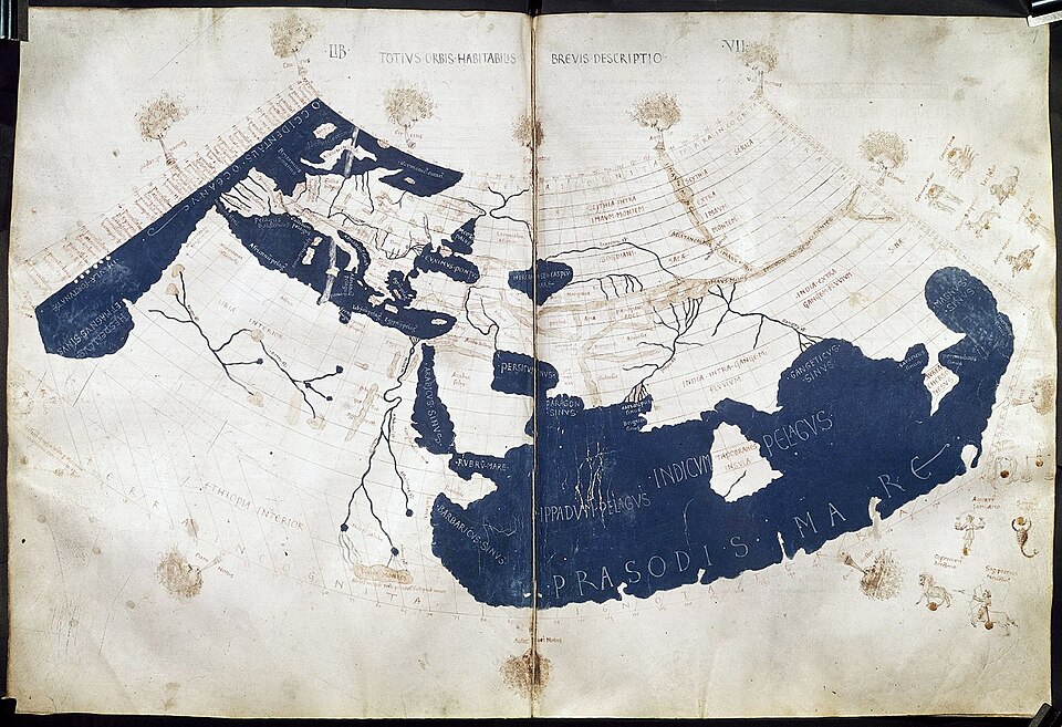
Blown off course on the return from his first trip to the Caribbean, Columbus made port and anchored in Lisbon. Eager to lay claim to his “discovered” route to India and assert his privileges as Admiral of the Ocean Seas, he wrote to King João II of Portugal asking for permission to enter the Tagus River. At his royal audience, as proof of his discovery, he presented Taíno captives, human beings produced as material evidence of an exploratory feat rather than as evidence of humanity’s expanded domain. Through a calculated lapse of understanding — be it willful or structural — the Indigenous Caribbean body was transformed from a human subject into material and mistaken evidence of a new route to Asia. Thus, the indio arrives: a figure birthed from cartographic fantasy and sustained by geographic error.
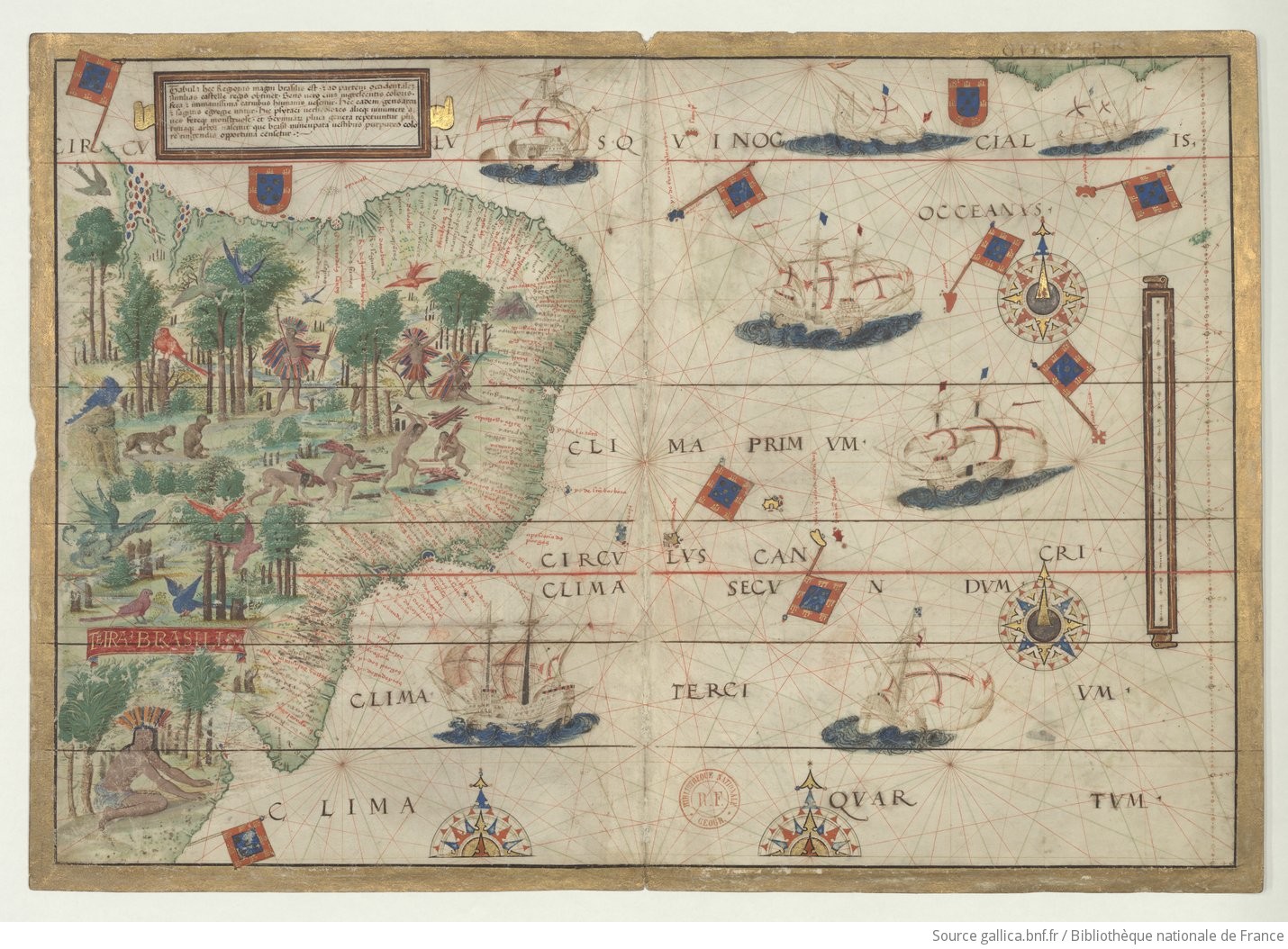
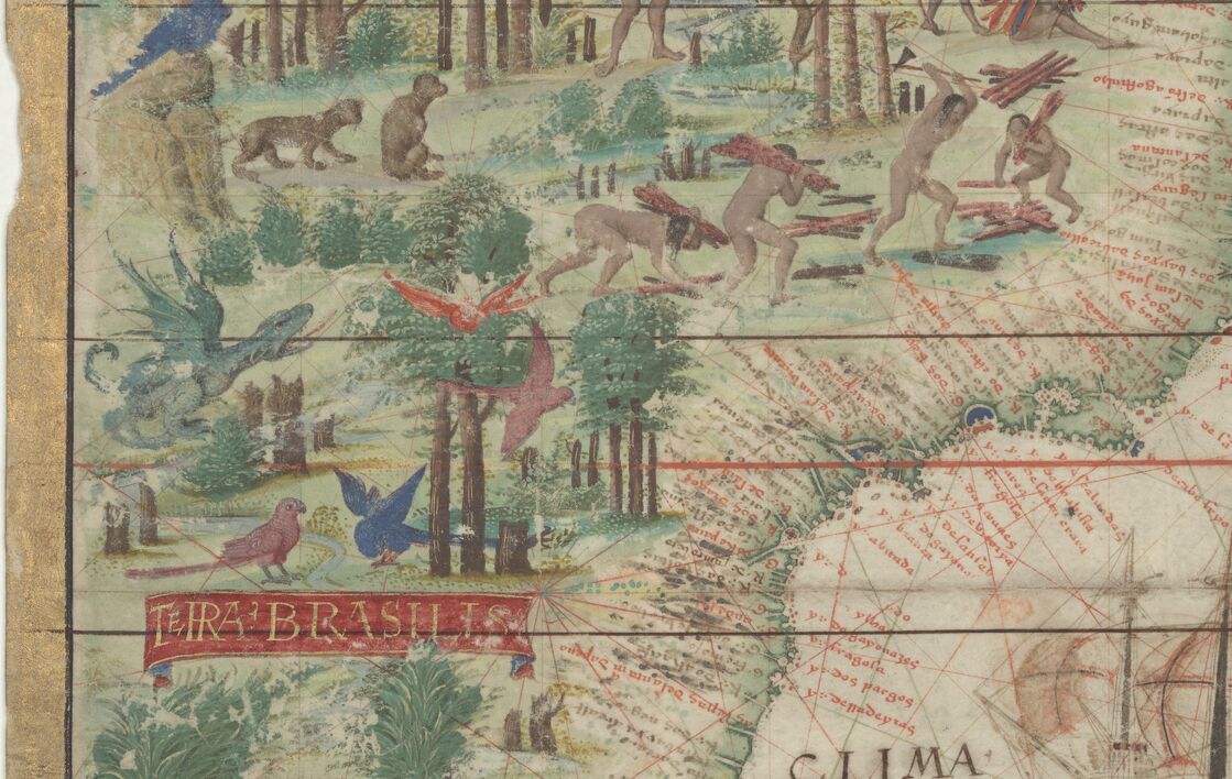
In the 16th century, as the cartographic imagination expanded with the growing exploration of coastal routes, so did visual knowledge regarding people, flora, and fauna. As cartography reflected newfound territory and mapped people onto those lands, it generated new ways of categorizing space and bodies. To demonstrate authority and completeness, these new methods incorporated prior knowledge of things and beings already known to exist through myth, natural histories, and canonical truths. This new order of constructing the world through the visual produced ways of processing the difficult abstractions of colonial encounter, rendering them real and material. Maps displayed the reach of territory and its inhabitants, both real and imagined, even while the boundaries of the earth remained in question. The Miller Atlas (1519) combines the imperial naval dominance of the Portuguese fleet with the tenuous, contingent fringe of Brazilian greenery, populated by Indigenous bodies and a fierce green dragon roaring from the jungle. By placing the Indigenous body in the same visual register as the mythical beast, the atlas categorized the indio as a fixture of natural history rather than a political subject.
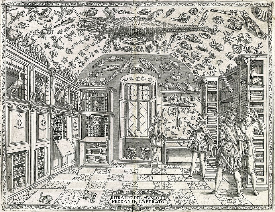
The ships that carried Europeans across the Atlantic returned with vast quantities of visual and material data, which were added to existing collections that organized the world through strange and fascinating objects. Wealthy families maintained collections of unfamiliar and exotic objects from the expanding colonial reach into distant domains. The Kunstkammern (art rooms) and Wunderkammern (wonder rooms) organized knowledge into repositories of the strange — exceptions to the rule rather than data from which a rule could be derived. These collections of organic and inorganic wonders crowded unfamiliar objects into a single ontological realm, creating a cognitive shock that eased the categorical domains generated through imperial vision. Shells from the Indian Ocean, animal skins from Africa, and feathers from New World birds all became metonyms, not only for distant places but for the people who inhabited them. This metonymic reduction — where a feather stood for a soul — allowed European artists like Hans Burgkmair to populate visual narratives of the “Other” without ever leaving their hometowns. Oral, textual, and material evidence were fitted into the European imagination to produce a curated, ethnological “Other” long before law codified it.
As voyages expanded south beyond West African shores and into the Malabar coast, a more immediate administrative need developed to record encounters. For the captains, merchants, and friars of the Iberian Empire, it became necessary to catalog everything, as any object or person could be of profitable use to the Crown. Distinguishing between kinds of people meant distinguishing between kinds of places; these distinctions allowed for the organization of the “civilized” from the merely incidental. While the caravels, naos and carracks carried traders and clergy, they rarely carried artists. Instead, the empire relied on artists and artisans who, like birds, roosted in port cities or nested in the creative traditions of the colonies. A notable exception to this shore-bound production is the Livro de Lizuarte de Abreu (MS M.525); unlike most colonial catalogs, large portions of this manuscript appear to have been painted at sea onboard a Portuguese nao. This rare instance of “gallery-on-water” provided a more immediate, though no less imperial, capture of the unfolding horizon.

In New Spain (Mexico), this visual record-keeping shifted as Spanish colonial officials began relying on Indigenous Nahua practices. It is here that the visual indio of the cabinet of wonders begins to collide with the legal indio of the colonial court. As Nancy E. van Deusen argues, the “global indio” emerged not as a static ethnic identity, but as a legal evidentiary standard that circulated throughout the Iberian Empire. This status was contingent and often proved through “fame and public report” — a collection of visual, oral, and textual proofs that determined a person’s rights and obligations from Manila to Seville.
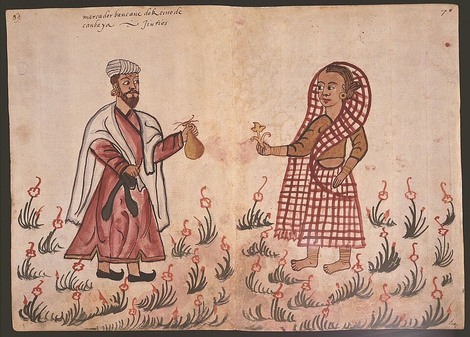
This “global indio” finds its most striking visual expression in the Codex Casanatense and the Boxer Codex. Though separated by nearly half a century and the vastness of the Pacific, both manuscripts function as administrative field guides for an empire that needed to distinguish between “vassals,” “infidels,” and “miserables.” The Codex Casanatense (ca. 1540), likely produced in Goa, captures the diverse inhabitants of the Indian Ocean through granular attention to dress and custom, providing the visual data necessary to categorize diverse peoples under a singular imperial rubric. This reached its apex in the Boxer Codex (ca. 1590), where the indio status is explicitly tied to legal portability. By standardizing the appearance of various groups in the Philippines and across the Pacific, the Spanish administration could more easily apply the legal frameworks of the República de Indios. These codices were the visual databases of a global legal bureaucracy that utilized the indio as a universal unit of colonial management.

However, this categorization was not just an identity imposed from above. In the wake of the conquest, the Spanish administration established the República de Indios, a legal framework that afforded Indigenous communities a degree of corporate autonomy while simultaneously classifying them as miserables (legal minors). To navigate this system, the Nahua relied on the tlacuiloque — trained scribe-painters — to translate Indigenous history and land claims into a format legible to the Spanish court. The Nahua understood that if they could visually demonstrate their status as “noble indios” or “vassals of the Crown” through genealogies and mapas, they could secure land titles and tax exemptions. By “performing” the role of the colonial subject through the very markers the empire used to categorize them, the Nahua transformed the indio from a cartographic fantasy into a potent, localized legal agency.

Sahagún, Bernardino de, et al. Historia general de las cosas de Nueva España (Florentine Codex), Ms. Mediceo Palatino 218–20, Biblioteca Medicea Laurenziana, Florence, 1577. Digital Florentine Codex, edited by Kim N. Richter et al., bk. 11, fol. 221v. Getty Research Institute, 2023.
From Fantasy to Forensic Reality
The trajectory of the “indio” across the Early Modern world reveals a profound transformation from a geographic accident to a sophisticated tool of global governance. What began as Columbus’s “calculated lapse of understanding” was rapidly codified through the visual and material taxonomies of the Wunderkammern and the Miller Atlas. By flattening the diverse complexities of human life into metonymic objects, the Iberian Empire created a curated “Other” it could manage and categorize. As the Codex Casanatense and the Boxer Codex demonstrate, this visual mapping eventually matured into a portable, global evidentiary standard that defined the boundaries of the Early Modern global world. Yet, the Nahua tlacuiloque proved that the tools of imperial vision could be repurposed as instruments of Indigenous agency, utilizing the legal protections of the “indio” to ensure the survival of their communities. Ultimately, the indio was never a single people or a fixed place; it was an evolving visual-legal archive.
Ramón de Santiago (History of Art; CLACS Graduate Affiliate 2025-26) researches the trans-Pacific transfer of visual and material culture between South Asia, Southeast Asia, and Latin America in the Early Modern period, with a particular interest in pre-colonial systems of inscription in the Atlantic, Indian Ocean, and South China Sea. De Santiago’s current project uses multidisciplinary methods to investigate the layers of exchange of objects, goods, and people through Early Modern imperial world oceanic systems.
Works Cited
Abreu, Lizuarte de. Livro de Lizuarte de Abreu. MS M.525, 1558–1565. The Morgan Library & Museum, New York.
Boxer, C. R. “A Late Sixteenth Century Manila MS.” The Journal of the Royal Asiatic Society of Great Britain and Ireland, no. 1/2, 1950, pp. 37–49. JSTOR,
Boxer Codex. MS 21253, ca. 1590. The Lilly Library, Indiana University, Bloomington.
Burgkmair, Hans. Peoples of Africa and India. 1508. Woodcut series. British Museum, London.
Códice Casanatense (Album di disegni, illustranti usi e costumi dei popoli d’Asia e d’Africa). MS 1889, ca. 1540. Biblioteca Casanatense, Rome.
Homem, Lopo, Pedro Reinel, and Jorge Reinel. The Miller Atlas. 1519. Manuscript on parchment. Bibliothèque nationale de France, Paris.
Leitch, Stephanie. “Burgkmair’s Peoples of Africa and India (1508) and the Origins of Ethnography in Print.” The Art Bulletin, vol. 91, no. 2, 2009, pp. 134–159.
Van Deusen, Nancy E. Global Indios: The Indigenous Struggle for Justice in Sixteenth-Century Spain. Duke University Press, 2015.


Leave a Reply